History of Our Area
Our grateful thanks to Dennis Baldry for content to date.
If you have any more information about our area please let us know.
Sources
There is no comprehensive history of Belmont and South Cheam. The material in these notes has mainly been assembled from the following sources:
- Three books which reproduce old postcard views:
- Frank Burgess: Cheam, Belmont and Worcester Park, a Pictorial History (Phillimore, 1993)
- Patricia Berry: Cheam and Belmont in Old Photographs (Alan Sutton Publishing, 1993)
- A Century of Sutton (Sutton Publishing, 2000)
- Two local church histories:
- C Leslie Craig: Splendid the Heritage - the story of Belmont and its Methodist Church (1965)
- Margaret Reed: A Village Church - the story of the first 75 years of St John’s with Belmont Methodists (1992)
- Robert P Smith: A History of Sutton AD 675-1960 (D W James, 1970) - has information on the roads and the Warren
- Histories of local railways, including Mitchell & Smith on London suburban lines and Oppitz on lost [sic] railways
- Gareth Edwards: The Story of Belmont Hospital 1853-1959) - mainly about its time as a psychiatric unit
- Cherry & Pevsner: Buildings of England: London South (1983) - not good on this area
- Old Ordnance Survey maps
- Post Office directories (in Sutton Library) - difficult to use, as houses did not originally have numbers
- A (battered) copy of the original Belmont Estate plan
- Various personal reminiscences, notably John London’s.
See also the Wikipedia entry for Belmont.
More details of the history of South Cheam and in particular The Burton Estates ASLC (Area of Special Local Character) are given in the Burton Estates Character Appraisal document.
1 Early times
Pevsner writes: ‘Traces of neolithic huts have been reported on the Downs, and there is certainly considerable material of the period over the area. There are also several barrows on the Downs: four bowl barrows form the Galley Hills, but these are much disturbed by the golf course. One skeleton is all the reported finds.’ These barrows are in a coppice on the west side of the Brighton Road.
Three major north-south routes probably date from ancient times: Brighton Road and two droveways: Sandy Lane and Burdon Lane. These originally ran to junctions with Brighton Road but the south end of Burdon Lane was closed and taken into the golf course in the late 1960s, while the Downs end of Sandy Lane was never more than a track. Berry writes that Burdon Lane was named from a stream on this line. But Burdon means ‘fort hill’, and it may be significant that it joined the main road close to Galley Hills. Another old trackway, visible on the oldest maps, is on the line of Avenue Road, York Road, and Gander Green Lane.
Map 6 (below) shows Roman and Saxon burial sites on Banstead Golf Course. A few years ago another Saxon burial turned up in a garden on the west side of The Crescent.
2 Local Government
Our area formerly consisted of the south parts of the old parishes of Cheam and Sutton, and borders on common land, Banstead Downs, which the inhabitants used for grazing. The downs also harboured thieves: travellers heading towards Reigate used to see a gibbet, where highway robbers were hanged, near the Banstead crossroads.
In 1928 Sutton and Cheam became an urban district council (UDC) within the county of Surrey. In 1934 it received the borough charter. Together with Carshalton and Wallington UDCs, the Greater London Borough of Sutton was formed in 1965. More recently, a boundary adjustment took in Commonside Close, off the Brighton Road, formerly a coal siding.
3 From the 17th century to the 1860s
By the 17th century Banstead and Epsom Downs were a popular area for coursing. In the 17th century (Pevsner) a warren was built in the land between Burdon and Sandy Lanes. A keeper bred hares which were released for hunting through hatches which can still be seen at the base of the brick walls. Entry to the warren was by the keeper’s cottage (Plates 1-2 below). There is a kink in the line of Warren Avenue at this point and it continues westward on the inside of the wall. The cottage was demolished in 1930. Gaps were made in the wall when Warren, Onslow, and Wilbury Avenues were developed. The substantial remains are protected by Grade II listing.
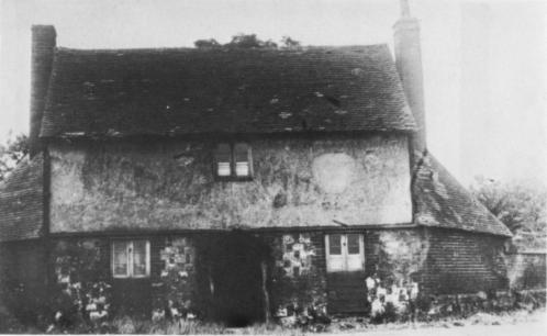
Plate 1: Hare Warren keeper’s cottage
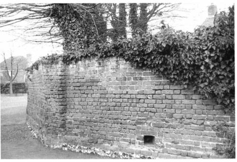
Plate 2: Warren wall with hatch
By the 18th century Banstead and Epsom Downs were popular for point-to-point racing (The Oaks horserace was named after a former mansion in Oaks Park, on the road from Banstead to Purley.) Craig states that the alehouse used by shepherds and drovers on the site of Belmont Station, shown as Little Hell on John & Peter Andrew’s 1762 Surrey map, had a gambling cellar under a trapdoor and down six steps. He mentions another alehouse, The Running Horse, in Downs Road, on the west corner of Clifton Avenue.
In 1745 Brighton Road became a turnpike. Milestones can be seen at Sutton Green and on the west side of Brighton Road near Basinghall Gardens. Another, marking 14 miles from The Standard in Cornhill, survives in a garden on the east side of The Crescent, well away from the present line of the road. The tollgates near Sutton Lodge were removed in 1882.
Early one-inch Ordnance Survey maps (1819 and 1868 - Maps 1 and 2 below) show various roads and some other features which can still be identified. They include the Hare Warren, a cottage, part of which survives as an outhouse behind 20 Station Road and The Crescent, a farm called Hundred Acres (on the site which became first Banstead Asylum and is now two prisons), and Sutton Lodge, then the seat of a farm estate on the east side of Brighton Road. 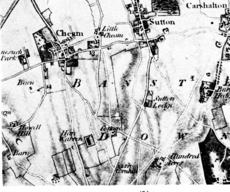
Map 1: 1819
In the mid-19th century our area included parts of two estates:
- Sutton Lodge to the east of Brighton Road, and
- land belonging to the Northey family (after whom Northey Avenue was named) to the west with tenant farmers.
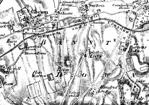
Map 2: 1868
Craig writes that there were fields growing peppermint, lavender, and strawberries near Station Road, and cornfields on the way north to Cheam village. He mentions two windmills: at Hundred Acres and at three cottages on a site by the corner of Station Road and The Crescent. This site is called The Folly on an 1871 map, and was surrounded by a wall. One outbuilding remains, on a different alignment from Station Road (Plate 3 below).

Plate 3: Folly cottage remains
The 1871 map (Map 3 below) also shows the three chalk-pits with a limekiln in Downs Road. Craig states that John Gibbons, grandson of the woman who owned the Little Hell alehouse on Brighton Road, bought eight acres, including these pits, in 1849. Four workers’ cottages (Plate 4 below) were later built in the pits, where California Court now stands. Clapham Lodge (now surrounded by houses in Bawtree Close off Banstead Road South) is also shown.
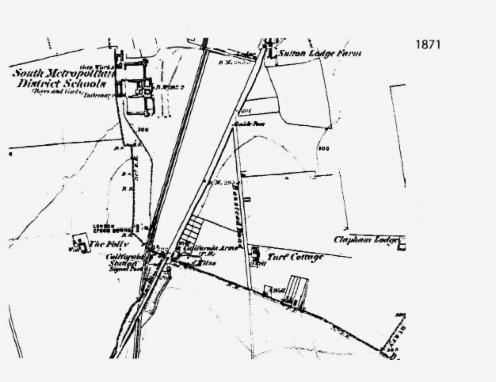
Map 3: 1871
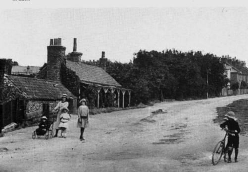
Plate 4: chalk pit cottages, c1900
The 1871 map shows Turf Cottage in Banstead (now Cotswold) Road, and, further up Downs Road, one or more cottages for the shepherds of Overton’s Farm (Craig).
In 1852-3 an establishment to educate poor children, the South Metropolitan District Schools (as further recounted below) was built to the west of Brighton Road (on the site of the Balmoral Road estate.)
Reed and Berry relate that in 1850 John Gibbons fled to America to avoid a trial for poaching a pheasant on the Northey Estate in Cheam. Gareth Edwards mentions an alternative tradition that Gibbons funded his journey by finding Roman coins while working in a quarry at Epsom. He followed the Gold Rush to California, where he made his fortune by running a supply store for the miners. Returning around 1860, he built the California Arms (Plate 5 below) on the site of The Belmont dining pub.
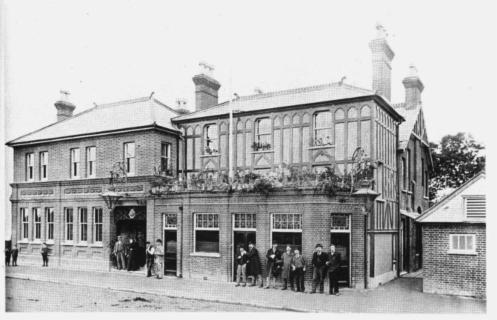
Plate 5: the California Arms
The six cottages on the south side of Downs Road were built in 1888 for the use of Sir John Hartopp’s servants (Craig). A leaflet issued by Banstead Commons Conservators relates that in 1873 Sir John Cradock Hartopp Bt from Yorkshire bought 1700 acres of Banstead Commons. He planned to purchase the commoners’ rights and enclose and develop the most suitable parts. Turf, top soil, gravel, etc were to be removed and sold from Banstead Heath, and houses built. To stop this, local residents formed Banstead Commons Protection Committee in 1887. Legal action followed, culminating in Sir John’s bankruptcy. In 1893, Parliament passed the Metropolitan Commons (Banstead) Supplemental Act, protecting the downs from further development. The first meeting of conservators took place on 7 July, chaired by the Hon Francis Henry Baring.
4 Public transport
In 1864-5 the London Brighton and South Coast Railway Company built the Sutton to Epsom Downs line under statutory powers. Brighton Road was realigned eastward to facilitate construction of a bridge over the line. Further north, a bridge (rebuilt 1984) carried Homeland Drive over the railway, but at the station originally called California there was only a level crossing until 1888. Mothers with perambulators preferred to use Homeland Drive.
Like that which goes to Tattenham Corner, this line was designed to be a link to Epsom Racecourse, but local passenger services were provided. A shuttle service - an engine and two coaches - ran between West Croydon and Belmont, and on later to Epsom Downs.
The railway also carried goods traffic. There were sidings on both sides of the track at ‘California’. That on the west served the South Metropolitan District Schools, which had their own narrow-gauge railway link, but was taken up around 1890. That on the east was resited twice, before ending up in Mr Jones’s coal yard (Plate 6 below).
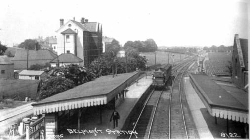
Plate 6: Belmont Station, showing the shuttle train and eastern siding
When Banstead Asylum was built in 1873-7, with its own gasworks, coal and other goods were carried to it on a paved cart-track which can still be seen at the edge of The Downs. In 1889 this siding was transferred to the coal yard (on the site of Commonside Close). The siding closed in 1969, and the coal yard (then Charringtons’) went around 1973.
The name California is alleged to have caused confusion, with goods being misdelivered to America. In 1875, the station was renamed Belmont, after the new estate.
The line was electrified in 1928, but was reduced to single track in 1982. The station then became an unstaffed halt, with one service an hour in each direction (two in the rush-hours), and none on Sundays and Bank Holidays (since improved!).
The stand at the corner of Brighton and Downs Roads is a long-established terminus for bus services. In 1996 new services were introduced, going through areas away from the main roads and using small single-decker buses.
5 The Belmont Estate
Several writers have speculated that the name Belmont was a reaction to ‘Little Hell’. This is unlikely, as the alehouse must have disappeared when the California Arms and Belmont Station were built some years earlier. In fact, ‘Belmont was popular as a street name in London in Victorian times, mainly for its pseudo-Norman associations (“fine hill”)’ (Adrian Room: Modern Placenames in Great Britain and Ireland, OUP 1985).
In 1865 Marshall N Inman, architect and surveyor of 7 Bedford Row, London WC, acquired rights to acquire and develop land between the railway and Burdon Lane and called his project The Belmont Estate. It extended on the south to the edge of Banstead Downs and on the north as far as Dorset Road. Copies of his plan (Plates 7-8 below) exist among the deeds of older houses in Belmont, and Sutton Library has one awaiting conservation. Another version is visible as a billboard in the photograph of the foundation ceremony for St John’s church (plate 12 below).
The scheme amounted to a new suburb, with its own church and a Royal Hotel (never built). The housing layout provided for terraces in Belmont Road and Kings Road, semi-detached houses in the lower part of The Crescent and Redcliffe Road (never built - roughly on the line of Belmont Rise), and detached houses in Queens Road, the southern end of The Crescent, and Burdon Lane. There was no provision for a school (primary education did not become compulsory until 1880).
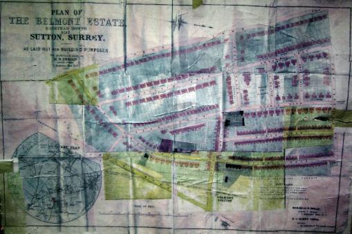
Plate 7: Inman’s Belmont Estate project
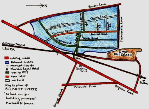
Plate 8: key to the plan above
The scheme is comparable in scale to the 1920s-1930s Stoneleigh Estate. But unlike Stoneleigh, it hung fire for thirty years. The 1897 OS map (Map 4) shows merely eight semi-detached houses (nos 17-31) and Ayott Lodge (no 38) in The Crescent, and terraces on the east sides of Belmont Road (which was initially called Queen’s Road) and of Kings Road. Yet although the estate was never completed as planned, it shaped the area. Later building followed Inman’s road layout and freehold plots were sold as set out in his original plan.
6 Early development around Downs Road
Up to the end of the 19th century, the centre of our area was the corner of Brighton Road and Downs Road. Pre-dating any shops in Station Road, three were built between The California Arms and the corner. The earliest appears to have been the corner shop, originally the Belmont Post Office belonging to W H Brain. A view in Burgess shows the VR pillar box alongside this shop. In a 1910 picture a fourth shop has filled the gap and the pillar box is no longer visible. The VR pillar box was relocated to Station Road, but unfortunately was struck by a large vehicle in 2015 and was damaged beyond repair. It was replaced by a modern ER pillar box.
Round the corner in Downs Road, from around 1875, a number of houses were built beyond the chalk pits, starting with two terraces, each of five houses. Others were built beyond these.
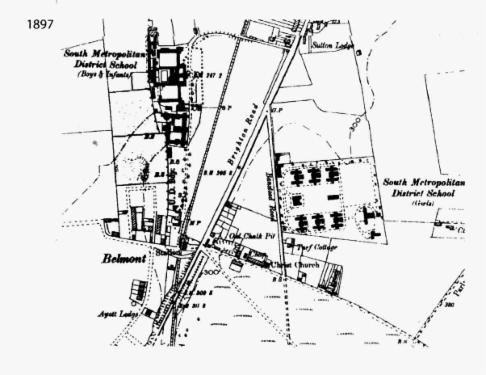
Map 4: 1897
Map 5: 1903
7 Schools
The South Metropolitan District Schools (Plate 9 below), built in 1852-3 on the site of Balmoral Way and Homeland Drive, provided vocational (‘industrial’) education for up to 1500 poor children from Greenwich, Camberwell, and Woolwich.
In 1882-3 the schools acquired from the Sutton Lodge estate a site on Banstead (now Cotswold) Road for a separate girls’ establishment. This was in six blocks, each housing 100 girls. Some of these remain as parts of the London Cancer Hub.
The original schools closed in 1902. After a brief period as a hospital and asylum they became Belmont Workhouse in 1908. Conditions for inmates were harsh, and in November 1910 three hundred of them staged a riot (Gareth Edwards). In1915 the buildings became a hospital for German prisoners of war and a house of internment for enemy aliens. After reverting in 1922 to a workhouse for unemployed men, in 1930 they were taken over by the London County Council as a training centre for the unemployed. They became the Sutton Emergency Hospital in the Second World War. In 1946 they were turned over to psychiatric medicine and became known as Belmont Hospital. In the 1950s the Henderson Hospital was built as a residential home for 29 people with mental health problems. The main blocks were demolished in the 1980s and redeveloped for housing, now known as Belmont Heights. The Henderson Hospital remained until 2016 when it was demolished and redeveloped as town houses (Hardegray Close) and also a Health Centre (opening 2022).
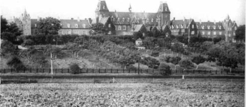
Plate 9: South Metropolitan District Schools, later Belmont Hospital
Banstead Road primary school, in what is now called Cotswold Road, was the original Belmont school, built in 1897 with 150 places. More recently it catered for pupils with special needs, but the site has now been redeveloped as Baron Close.
Belmont village primary school, also with 150 places, was built in 1902, in Avenue Road, on part of the site originally designated for a church. The present Avenue School was established in 1956 and progressively enlarged. It is now the Avenue Academy. The original building ceased to be used around 1970, and is now the private Hopscotch Nursery.
Overton Grange on Ventnor Road was opened in 1997 as a mixed comprehensive secondary school.
In 2019 a new secondary school, the Harris Academy Sutton, with a capacity for 1275 pupils was opened on the site of the old Sutton Hospital.
8 Churches
The growing population became a target for voluntary church missions. A Miss Hale started a Sunday school, first in a room, then in a barn as numbers grew to 100. In 1889, asked to leave the barn at short notice, she managed with friends’ help to buy an iron church building (Plate 10 below) for £30, and to buy a plot just above the chalk pits from Mrs Gibbons. A house is now on this site. The Belmont Mission church was at first interdenominational, then Baptist.
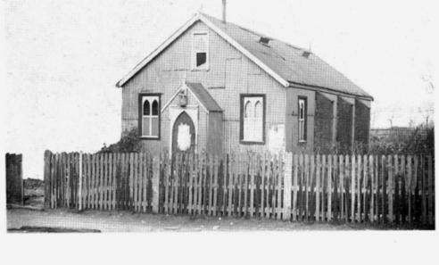
Plate 10: Free Church Mission Hall
In 1880, an Anglican Mission and Parish Hall (Plate 11 below) was built further up Downs Road, under the auspices of Christ Church, Sutton, and St Dunstans, Cheam. After St John’s parish church opened in 1916, the Downs Road building remained the parish hall. It was rebuilt in 1940.
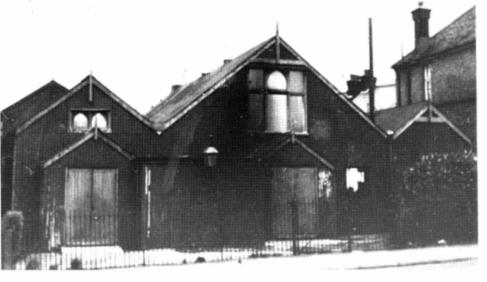
Plate 11: C of E Mission Hall
When the present hall in Northdown Road opened in 2004, the old hall became a drop-in centre. When the Belmont Estate finally took off, both churches needed permanent sites, and these were available in Station Road. A public meeting in 1908 set up a building committee for a parish church and the site was purchased in 1910. The Belmont Estate plan envisaged a church, with a vicarage behind, near the south end of Avenue Road. The eventual site closes the western vista up Station Road. Architects were appointed, and the foundation stone was laid in July 1914 (Plate 12 below). There were not sufficient funds to built the tower originally planned, and the west end was a temporary structure, not finished until 1967. Belmont became a self-governing parish in 1920.
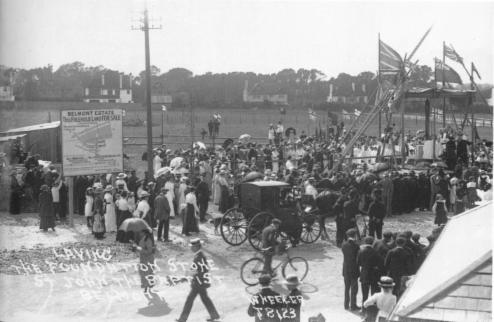
Plate 12: foundation stone ceremony, St Johns
The Free Church bought the site on the corner of Kings Road which is now Deacon House, and the foundation stone was laid in July 1915 in the presence of representatives of local Methodist, Baptist, Congregational, and Evangelical churches. The church, which had a hall alongside (Plate 13 below), was opened that November. In 1928 the congregation affiliated to the Methodists. After the Second World War there was growing collaboration with the Anglican congregation at St Johns, while the cost of maintaining the Belmont Methodist Church became unsustainable. In 1986 the two churches agreed to share St John’s. Sale of the site paid for adaptations at the parish church to cater for Methodist services and meetings.

Plate 13: former Methodist Church and Hall (on right)
Around 1910 the Roman Catholics also envisaged building a church, and bought a site at 3 Queens Road. Later they sold this to the Methodists, who built their manse there. It is now a private house. For many years the Catholics held Sunday services in the chapel of Belmont Hospital, the former South Metropolitan District Schools. They no longer have a place of worship in Belmont.
St Andrew’s Presbyterian Church in Northey Avenue was built in 1924-7, with additions in 1931-3 and 1956. It is now affiliated to the United Reformed church. Though the congregation has diminished since it was built, it provides meeting spaces for a variety of local organizations, including the BSCRA.
The date of the war memorial at the corner of Station and Queens Roads is not recorded, but it had been erected by 1923. In 1927 the vicarage was built on the newly opened Belmont Rise.
9 Social and sports clubs
The Downs Golf Club was founded in 1890. It moved in 1899 from a tin hut near Banstead railway cottages to its present building in Burdon Lane.
The Constitutional - now Belmont Conservative - Club existed by 1910 and was originally located at 37 Station Road. It subsequently moved to its current location on on the corner of Kings Road.
The British Legion Club by the railway bridge (8 Station Road) was built in the 1920s on land donated by a local builder for the benefit of the people of Belmont. The hall fell into disrepair and was demolished and redeveloped as a block of 7 flats in 2014. The Royal British Legion - Belmont Branch now has its headquarters in the Belmont Conservative Club.
In 1926 Cheam Lawn Tennis Club opened in Holland Avenue
10 Belmont Estate comes of age
Sites in the Belmont Estate were gradually taken up. Craig states that Nos 14-20 Station Road were built between 1879 and 1884, new terraces were built in Belmont Road with the dates 1884 and 1888, and on the north side of Station Road shops were built around 1890 on the east corner of Kings Road and the west corner of Belmont Road. Deeds show that Marshall Inman’s heir acquired parts of the estate in 1898 with a view to developing them. Semi-detached houses were built at the lower end of The Crescent from around 1900, and in 1904 Mr Alfred Belcher was employed ‘to cut out’ The Crescent and Queen’s and Northdown Roads and ‘plant their verges with trees’. His greengrocery shop at No 31 Station Road, now part of the Conservative Club, was built in the same year.
The original shopping centre was on Brighton Road, between the California and the corner of Downs Road, where the post office was until about 1907.
Most of the shops and terrace houses in Station Road, and the terrace round the corner in Avenue Road, appear to have been built by the first World War. The first Station Road shops were The Parade circa 1900, on the south side between the bridge and the corner of The Crescent. A picture shows one of these as a dairy and post office. The shops at the end opposite the church appear to be of similar date.
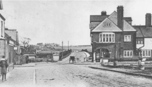
Plate 14: Belmont - Station Road c1900.
By 1920 the post office had moved from the corner of Brighton and Downs Roads to one of the original block of Station Road shops, which was also The Creamery. It subsequently crossed the road to 29 Station Road which closed in 2005 when the Post Master retired. At that time the pillar box bore the royal initials VR, so must have moved with the post office from Brighton Road. As mentioned earlier the Victorian pillar box was damaged in 2015 and replaced with a more modern ER design. A new Post Office branch opened in April 2018 at 37 Station Road but closed again in 2019 due to ill health.
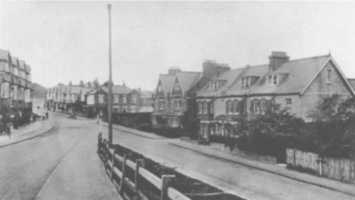
Plate 15: Belmont - Station Road from the bridge c1930.
Nos 32-34 Station Road were not developed at this time. Mr Belcher had his plant nursery here and in the wedge of back land between the houses in The Crescent and Queens Road. Around 1939 the frontage was acquired by the Post Office to build a telephone engineering depot. In the 1970s this became redundant and was let as offices. Finally the site, including London and Belcher’s nursery at the back, was redeveloped as flats - California Close - in a style which harmonizes with the original Station Road shops.
The Edwardian period saw development spread with detached houses up The Crescent and at the top of Burdon Lane. On the other side of the railway, semi-detached houses in Pelton Avenue and Cotswold Road appear to be of similar date.
In the 1920s and 1930s, new development started to fill the gaps between Belmont and Sutton. From 1923, detached houses were built in Avenue Road. The construction of Sutton bypass - Belmont Rise - in 1927 cut through the Belmont Estate. Along York Road, which was developed after World War 2, there were previously fields where Colmans of Norwich grew garlic.
The high point of Belmont as a self-contained village community was the period between 1910 and 1970. At this time Station Road had a wide range of shops. The ‘Coach House’ behind Nos 26-28 was actually the local butcher’s slaughterhouse - fittings survive in the basement of his former shop. No 20 was a fishmonger’s.
In 1970 Belmont shops still provided a wide range of services. The baker at No 18 made his own bread and cakes. There was a bank branch on the corner of Belmont Road. No 22 was a draper’s. There were also a greengrocer’s, a confectioner’s, and an ironmonger’s.
Today shops providing for most basic needs remain, though the branch post office closed in 2005. But a number of shop premises are now offices, with retail as a sideline. There are several restaurants, takeaways, and hair salons. However, Belmont’s position on the edge of the downs, with a small catchment area and limited car-parking space, is a limiting factor for shopping enterprises.
11 Development in South Cheam
Cheam Village is a predominantly 1920s suburb but its history can be traced back to Saxon times. It was mentioned in the Domesday Book, when the area belonged to the monastery attached to Canterbury Cathedral. South Cheam is that part of Cheam which is south of the Sutton-Epsom railway line and was for many years farmland.
The oldest structure in South Cheam is Cheam Warren. The area was once renowned for hunting and horse racing and the perimeter wall of the Hare Warren is one of the last surviving features. The wall now forms the boundaries of houses in Warren Avenue, Wilbury Avenue and Onslow Avenue. The brick wall is a Grade II Listed Building/Structure dating from the 18th century rather than Tudor, although it may be on older foundations.
The land of South Cheam primarily comprised two farms, Cheam Court Farm and Church Farm which were both part of the Northey Estate. The interwar period saw the break-up of the estate for financial reasons.
In the
late 1800s there were few roads in what is now South Cheam. The “major” road was
Burdon Lane which stretched south from CheamVillage
towards Banstead.
Sandy Lane existed as the track from
Cheam Court Farm House through the centre of that farm’s land to the
south. The section of Sandy Lane from
the railway line to the Northey Avenue junction is unchanged today from its old
route, but the section to the south of Northey Avenue was straightened by
Andrew Burton prior to building.
To the
east was the old farm track from Church Farm House (in Springclose Lane, Cheam) through the
centre of the land
of Church Farm. The northern section of this track is now the
A217 St Dunstan’s Hill and the southern end is now Manor Road.
The late 1800s and early 1900s saw a few houses being built at the northern end of Burdon
Lane as Cheam expanded south.
At the southern end of Burdon Lane, expansion of BelmontVillage crept along The Crescent and into the southern end of Burdon Lane. Some large Edwardian villas were built in the private road The Drive. To this day, some of the houses still consider their address to be "Belmont" reflecting their earlier heritage from before the A217 being built and cutting The Crescent into two.
Most of the original Edwardian villas in The Drive have now been demolished and rebuilt in a neo-Georgian style.
The 1920s and 1930s saw the bulk of the remaining area being developed by local Builder Andrew Burton. This area is now defined as the Burton Estate Area of Special Local Character (ASLC ). This area included The Avenue,
Shirley Avenue, the central section of Sandy Lane, the west side of the southern end of Sandy Lane, Golf Side and Downs Side.Today, these are regarded as the premium roads in the ASLC and those that have little or no in-fills and have suffered limited “blight”.
In the post WWII years, much of the remainder of South Cheam was completed. This comprised the east side of the southern end of
Sandy Lane, The Dene and the north side of High View. The southern end of Onslow Avenue and Wilbury Avenue were largely filled in and the properties on the southern end of Golf Side were built.The post war houses were still built in the Burton style but plots were typically more modest. Where in the 1920s two houses would have been built, in the 1950s three would be accommodated.
The east-west roads
Warren Avenue and Northey Avenue are mainly 1960/ 1970 back garden flank infills and have their own distinct characters. Warren Avenue has a locally listed group of 5 unusual 1970s houses. Northey Avenue is exclusively (chalet) bungalows.12 Health
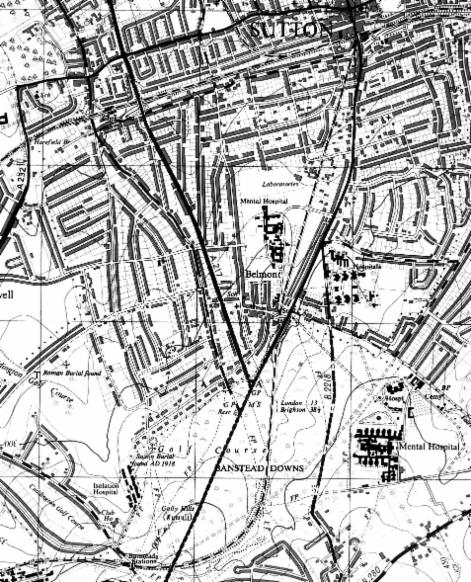
Banstead Asylum, later Mental Hospital, was built at Hundred Acres on Banstead Downs in 1873-7 (Plate 16 below). It was almost a self-contained community, with its own gasworks and sports ground. It closed in the early 1970s, to be replaced by two prisons. 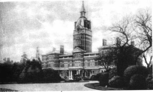
Plate 16: Banstead Mental Hospital
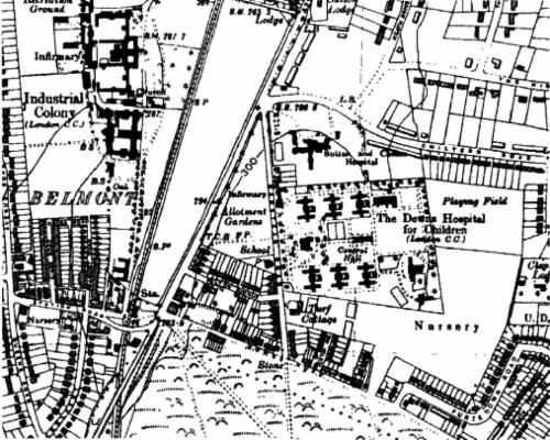
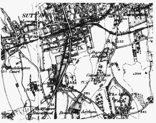
Map 6: 1938
The two South Metropolitan District Schools complexes came to be used as hospitals when they no longer served their original purpose (Map 6 above). The only remaining hospital uses on the Belmont Hospital site are the Henderson, a pioneering therapeutic community, and a nurses’ home.
Remaining buildings of the former girls’ industrial school on Cotswold Road have been taken over by Sutton Hospital and the Institute of Cancer Research.
Sutton and Cheam District Hospital was built on the corner of Chiltern and Cotswold Roads in 1930. It became part of the Epsom & St Helier NHS Trust group. The hospital became surplus to requirement and was purchased by the London Borough of Sutton who demolished the hospital and built a new secondary school (Harris Academy Sutton) which opened in 2019.
The Surrey branch of the Royal Marsden Hospital was built off Downs Road in 1962.
There is a GP clinic in Belmont Station Approach but this is due to relocate to new premises off Homeland Drive (Hardegray Close) in 2022. A dental practice was set up in Station Road.
13 Open spaces
Apart from the Banstead Downs, Belmont and South Cheam have three public open spaces.
In 1927 the Belmont Rest Garden land, on the corner of Northdown Road and Belmont Rise, was sold by the church to the local council.
A wedge of open land between Homeland Drive, the railway, and Brighton Road is shown as undeveloped on all maps earlier than the 1960s. There are wrought iron railings along the road side, suggesting that it was enclosed as part of the South Metropolitan District Schools site. Plate 6 appears to show a crop growing - perhaps lavender?
After the Second World War, a range of prefab bungalows was built along the whole length of the site (see Map 7). In the late 1960s the Council built the Shanklin Estate, consisting of flats to an innovative layout and a few terraced houses, at the Homeland Drive end. The southern part of the site was landscaped as Belmont Park.
Belmont Allotments occupy the land between Brighton and Cotswold Roads and Pelton Avenue.
At the south end of Overton Road are public playing fields, Overton Park.
A conservation area, Belmont Pastures, has been created between Knockholt Close and the railway. The Council describes this as a grassland site with some large old horse-chestnut trees and plenty of dead wood, home to a variety of wildflowers, butterflies, and moths.
14 The Second World War
The conspicuous buildings of Belmont Hospital made them a secondary target in the war. Gareth Edwards describes various damage to them by incendiary bombs. On 15 April 1941 a bomb destroyed the original California Inn and Belmont Station. 10 people were killed and many injured. Private Gibb was awarded the BEM for holding up debris in the inn for three hours until buried women were rescued. (Another bomb fell in London’s nursery behind Station Road.) The station building was replaced with a prefabricated ticket office, but this has subsequently been removed. The California was rebuilt in 1955 and was renamed The Belmont, a carvery restaurant and pub. After a recent refurbishment, the pub's name has been changed back to The California.
A plaque in Banstead Golf Club commemorates a pilot who crashed on the downs while avoiding the built-up area.
Cuddington Lane, a private road but public right of way linking Sandy Lane to Banstead Road Ewell, is said to have been constructed by Canadian forces stationed there.
Map 7: 1961
15 Notable former residents
James Blades OBE (1901-1999) orchestral percussionist, noted for recording the gong at the beginning of the J Arthur Rank movies (though this was mimed by Bombadier Billy Wells) and for the V-for-victory morse code on the timpani used by the BBC in WW2; often lectured to local schools; resident of Cheam, married to Joan Goossens.
Dr Jeremy Gerhard CB (born 1927 - 2004), lived in Cheam before appointment as Deputy Master and Comptroller of the Royal Mint (1977-88).
James Hunt (1947-93), world motor-racing champion 1976, grew up at Moorlands in The Drive.
Lord Judd (born 1935) lived at 42 The Crescent until he became director of Oxfam. As Frank Judd he was MP for constituencies in Portsmouth from 1966 to 1979. His mother, Helen Judd, stood against Sydney Marshall in 1945.
Don Lusher OBE (1923-2006), trombonist and jazz band leader, lived in Burdon Lane
Sir Sydney Marshall (1882-1973) lived at Bracklin, 66 The Crescent (site of Patricia Gardens). He served on Surrey County Council and Sutton & Cheam Council, and was the charter mayor in 1934. From 1945 to 1954 he was the first MP for the new constituency of Sutton and Cheam.
Lord Ritchie-Calder (1906-82), journalist and environment expert, once lived at 74 The Crescent (on the corner of Belmont Rise).
Lionel Tertis LRAM CBE (1876-1975), celebrated viola-player, and his wife Ada, lived at Smalldown, 63 The Crescent, from 1909 to 1937.
Barry Wordsworth (born in Cheam 1948), orchestral conductor - music director, Royal Ballet, 1974-95; principal conductor, BBC Concert Orchestra, 1989-2006, and of Brighton Philharmonic Orchestra; recording artist for Naxos.